All Articles
Hidden Treasure Mine—Foresthill Divide, California
September 2008 by Don Robinson
 One of the greatest and richest underground placer mines of California was the Hidden Treasure Mine of Placer County.
Additional articles that might interest you...
Legislative and Regulatory Update
March 2020
- NEPA comments due
- Update on latest US Supreme Court suction gold dredging appeal
- Washington State tries to restrict suction gold dredging
Long-Term Camping Plan at Fortymile Proposed by BLM
August 1999
A draft environmental assessment of a proposal to allow long-term camping by gold miners along 21 miles of the North Fork of the Fortymile Wild and Scenic River is available from the Bureau of Land Management.
A draft environmental assessment of a proposal to allow long-term camping by gold miners along 21 miles of the North Fork of the Fortymile Wild and Scenic River is available from the Bureau of Land Management.
Company Notes
February 2004
• TVI Pacific Inc.
• Sherwood Mining Corp.
• Rubicon Minerals Corp.
• Planet Exploration Inc.
• Goldcorp Inc.
• Placer Dome Inc.
• Wolfden Resources Inc.
• Redstar Gold Corp.
• Oretcch Inc.
• Goldspring Inc.
• McWatters Mining Inc.
• Cambior Inc.
• TVI Pacific Inc.
• Sherwood Mining Corp.
• Rubicon Minerals Corp.
• Planet Exploration Inc.
• Goldcorp Inc.
• Placer Dome Inc.
• Wolfden Resources Inc.
• Redstar Gold Corp.
• Oretcch Inc.
• Goldspring Inc.
• McWatters Mining Inc.
• Cambior Inc.
Cerro Colorado Silver, Arizona
November 1999
It was the first mine developed by Americans in the Cadsden Purchase of 1853. A number of small near-surface mines had been operated by Spaniards and Mexicans in the region prior to the arrival of Americans, going back as far as 1740.
It was the first mine developed by Americans in the Cadsden Purchase of 1853. A number of small near-surface mines had been operated by Spaniards and Mexicans in the region prior to the arrival of Americans, going back as far as 1740.
Placer PGMs in Coon Creek, California
November 2004
Lower Coon Mountain is located in the Klamath Mountains, some 10 to 15 miles east of Crescent City (pop. 4,400), which rises to an elevation of 2,841 feet. It is heavily forested except for a few areas that are underlain by serpentine. The mountain, which trends northeast, is bounded on the north by Craigs Creek, and on the south by Coon Creek.
Lower Coon Mountain is located in the Klamath Mountains, some 10 to 15 miles east of Crescent City (pop. 4,400), which rises to an elevation of 2,841 feet. It is heavily forested except for a few areas that are underlain by serpentine. The mountain, which trends northeast, is bounded on the north by Craigs Creek, and on the south by Coon Creek.
Summertime Gold! Northern & Southern California
 September 2023
The Rampart Goldfields, Alaska
November 2005
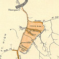 The town of Rampart, on the Yukon River, was established as a supply point after gold had been found on nearby Minook Creek in 1896. Rampart has been known by various names including Rampart City, Manook City, or Minook.
The town of Rampart, on the Yukon River, was established as a supply point after gold had been found on nearby Minook Creek in 1896. Rampart has been known by various names including Rampart City, Manook City, or Minook.
Subscription Required:
The Bawl Mill
• Legislative and Regulatory Update
• Ask The Experts—Columbium/Niobium
• Ask The Experts—How do I work this large quartz vein?
• Cashing In Your Gold: Working With A Refiner
• Our Readers Say
• Major Miners Go on Buying Spree
• The Big Gold Strike
• Gold Deposits Of South Carolina
• Investing In Junior Mining Stocks
• Bella's Birthday Nugget
• Jerritt Canyon Mine Lays Off 400
• Teenager Finds Large Nugget
• Winnemucca Rising While Other Towns Falter
• Melman on Gold & Silver
• Mining Stock Quotes
• Utah Mining History Being Erased
Free: